Thursday, April 29, 2010

Final death defying hike at Arches

For 2 months we have been putting off the longest hike until Friday when we finally decided it was the day. We started out at 8:40 in the morning with lunch and lots of water and walked the .3 miles from our cabin to the trailhead for Devils Garden trail.

There are several destinations that you can hike to and return or you could do the loop including a return by a "primitive trail". There's a lot to see along the way and several side trails to other views and arches.


From the trailhead to Landscape Arch is .9 miles on an easy trail that hundreds of people take every day. That's about as far as most people go. Not sure what keeps it from falling but don't think it will be long before it's a pile of rubble. Wall Arch just up the trail went down just last year. We have been up this far before but the trail was snow and ice and now it's just dirt and dust.

Just past Landscape Arch is Partition Arch. This is the view from one side and there is a trail that leads to the back side that we did not take.

From here on things started to get rough. As you can see, we had to go through the rocks, over some more...


We had to cross over some very high and narrow fins. It's hard to tell but this is about a 200' drop-off looking straight down on the trees below. Jackie just kept saying to herself, "don't look down, don't look down".


We ran across several areas with very unique erosion on the vertical surface of the Entrada sandstone.


Our first side trip off the main trail is Navajo Arch where me met a nice couple from Southern California and got them to take this picture for us. Or should I say this is for Michelle.


Another view from on top of the fins looking down into the valley of rocks that we have to find our way down and through to get back home, and we aren't at the half-way point yet.


A little closer view of what we will end up going through.

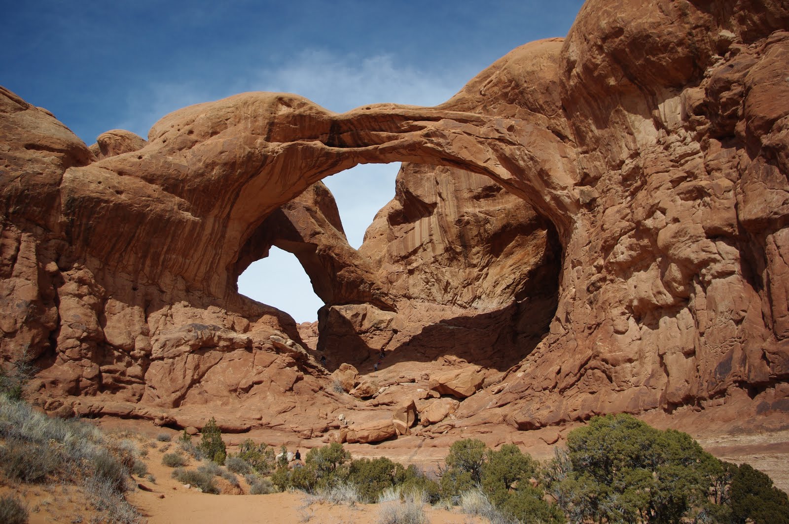
Just before the half-way mark we finally made it to Double O Arch and another picture of the two of us standing in the smaller of the two.

We went through the arch and climbed the hill for lunch and this shot looking back. The little hole at the bottom is the one we are standing in in the previous picture.

Two-thirds of the way around the loop we took another side trip to Private Arch. Hard to show all the beauty and size of some of the arches but we gave it our best shot.


Still trying to find our way out. Is it down the wash or do we climb up the rocks again? We keep trying and we will find our way out and back home.


Still an hour to go and finally get to the water hazard that we have heard about for weeks. This picture does not really show the size of the pond, the angle of the rocks and how slick the surface has been made by all the people slipping into the water. We met several people going the other way with very wet feet.
We worked as a team of 2 and finally made it across the face of the rock without wet feet.


We finally made it back to the trailhead and looking back at what we went through we are pretty proud of our accomplishment. We ended up doing between 7 and 8 miles and finally got back to the cabin in 5 1/2 hours. This is the longest hike we have ever taken together and somehow we survived. We didn't think we survived the next day when we tried to get out of bed, however. Seems we found muscles we didn't know we had! And the bottom of the feet--talk about sore!


To be continued...

Wednesday, April 21, 2010

More Arches

This "job" is very interesting. We use the word job loosely because it strictly a volunteer position. We share the duties with Robbie and Alice who are living in their 5th wheel at a campsite while we moved into a small cabin at the other end of the park. Our day starts with us heading out at 7:00 AM to walk the 1.3 mile round trip to set out the reservation slips at the sites and collect the ones from the sites where the people are leaving.

Back home around 8:00 and Jackie starts in on the daily reports so we can determine what sites (if any) will be available for walk in campers. We usually have campers coming to the door starting around 8:30 or 9:00 looking for a space for the day. We try and have some breakfast when we can fit it in.

We take the golf cart out at 10:00 (check out time) to make sure people are leaving and cleaning the sites for the next camper. We also pick up all the wood that is left over and bring it back to the cabin for our fires. We are back before noon where things slow down and we can get a shower and continue with the paperwork, this is the Federal Government.

We make more runs in the cart to check in campers and answer lots and lots of questions during the early afternoon. Around 4:00 we load up the cart with firewood and make another trip around the park trying to sell what we can. And we make another run at 8:00 to make sure all generators are off for the evening. If we feel it is necessary we will walk the campground at 10:00 to make sure all is quiet and then back home to bed and then start over again in the morning.

We work 4 days one week and then 3 days the next so have lots of off time to go and play. It's interesting and very easy work but some people can make the job very demanding at times. Like the people that try and sneak in at night and move into a reserved site.

___________________________________

Okay fans if you really want to enjoy all the details in some of these pictures you will have to click on them to enlarge them and see what's going on.

Another day, another series of arches here in the park. We went to the "Windows" area of the park early in our stay. We hiked around the area and took a close look at Turret Arch with a window next to it.

You can see that this was early in our stay because the snow was still on the trail


We hiked around the back side of Windows Arch and sure wished that the sky was not overcast, but you take what you can get. Got another picture of Jackie, this one from the side as most are butt shots.


The view from the front side of Window Arches. You can see these two arches from various spots around the park. Another shot of Jackie and other people to get a little scale in the picture.


Near the Windows Arch was a short hike to Double Arch. Dick just had to hand off the camera and try to climb up into the center section. He is not visible in this shot, but...


This is one of those pictures that you will have to click on and blow up to find him. It's interesting hiking up into some of these areas because when you get there it's always hundreds of feet down on the other side. This was no exception. Jackie was happy to stay on terra firma and take pictures.


No trip to Arches is complete without hiking to Delicate Arch. It's only a 1 1/2 mile hike but it's up all the way there. Again, if you blow up the shot you should see a string of people not only on the trail but going all the way to the top over the slick rock. Not the most exciting trail but it was an accomplishment to finally round the bend at the top as the arch comes into view.


Before reaching the top you can look across the canyon at another arch. Can you find the 3 people in this shot. Take a look and it will give you an idea of how large it all is.


When we finally reached the top there was quite a bit of wind blowing and a lot of people wandering around but WOW what a sight with the LaSal Mountains in the background.


Dick was able to get a quick shot without anyone posing under the arch. There is a huge drop off in front and behind. A lot of the people would not walk down under it because of the drop off and the heavy wind.

Dick got Jackie to pose for a picture but just as he was shooting a gust of wind came from behind and took her big straw hat and sent it down into the big bowl in front of her. This is another of those shots that you need to enlarge to see her trying to grab it as it sails away.


Dick yelled at her to smile as her hat sailed further away. We watched it go down over the edge into the bowl and then another gust caught it and we watched it set the hat down on the edge of the arch. Dick was able to very carefully climb out and retrieve it. All the people watching couldn't believe what they just saw. One person said he got it on film and was going to post it on UTube.


Another day we took a hike out onto the hills across from Delicate and this gives you another view of the size of the area and the drop off behind the arch. And this was shot with a long lens.


We will be out of here in about a week so will try and find the time for one more Arches blog before we depart. We've taken lots of pictures, but there is only so much time and space. We've been here for nearly two months and continue to be amazed at the scenery.


To be continued...

Tuesday, April 20, 2010

The quiz

I quess our little quizes are not for our readers as we only had 2 people who offered an answer. Last chance to see if you can figure it out.


Here is your answer, sorry it's not more exciting but we thought it was an interesting find out in the desert. No it's not a shot from space or lava flow.


It's just a closeup of a dead branch or trunk from an old Juniper tree.

Thanks for looking. Anonymous has the closest guess.

To be continued...

Wednesday, April 14, 2010

Shafer trail -- or There's No Turning Back

For those following this blog you don't get to see what the last picture of the last blog really is unless you take the time to guess. We will email a copy to Michelle as she was the only one to try and guess.

Last week we decided to visit Dead Horse Point State Park and Canyonlands National Park (Island in the Sky section) all in one day. We started early, took a lunch and headed out. From Arches to Canyonlands is only 33 miles (remember this distance).

At the State Park we enjoyed some amazing views down into the canyon and wow what a sight. While at the point we noticed a dirt road 1500' below us with a jeep running down it. If you look closely you will see parts of the road. Now look in the top right corner and you can see that the road looks like it ends at the base of the cliffs.

Don't be fooled. As you will see in some of the following pictures, it does not end there.

We headed to Canyonlands and this looks back over the valley toward Moab with Dead Horse Point State Park at the left, on top.

This is another shot looking back toward the State Park and there is that road down in the valley again, but looking the other direction. This road is the Shafer Trail, a former cattle and later a uranium mining road.

Heading back home to Arches we decided to try and see if we could make it down the 1500' cliff and find our way back on a "4 wheel drive jeep road". We started out at the top and the road took us about 3 miles on a narrow gravel road the was pretty level.
Then we realized there was no turning back as the road turned to a one lane road with no chance to turn around. We dropped 1500' in about 2 miles with switchbacks so sharp we had to back-up to get around the corners (and prayed we wouldn't meet another car, checking constantly below for vehicles coming up).


Check out this picture close and you will see one rig going up and one down trying to find a space to pass. We did the same thing on our trip down (did have one vehicle pass when we were in a "wide" space, luckily).


There are 4 bicycles on the lower section, and they will pass the truck before they get to the bottom.

When we finally got to the bottom, Dick was able to pry his fingers off the steering wheel to get a picture looking back at what we just came down. You can see the little white dot in the middle of what looks like a slide area; that's the truck that was going up the hill.


Now that we are at the bottom it should be a piece of cake to get back to Arches, NOT... Remember this is a 4 wheel drive, high clearance road and we still have a long way to go and it's going to get dark in a couple of hours.
When we could find the road, it was still up and down rocks. We had to watch every turn to make sure we could get in and out of the washes. At one point we lost the road and ended up going down the center of a wash that still was running with water!

The road was the worst that we have ever been on but the views here exceeded both of our expectations. At times we could look down onto the Colorado river. Even after dropping the 1500' we found that the river was another 1000' below us.

As we got closer to the end of this road we continued to view sights that we could not believe existed. The sun was getting low and the red hills started to glow.


Nature's erosion created sights that make you want to just sit and stare for hours.


The wall in the center of the picture looks like it was only about 20' thick. Not sure we would want to try and walk the top edge.

As you can tell by us posting this blog we finally made it to a paved road and then back to Arches. It took us over 2 1/2 hours and when we got back we realized we had traveled 33 miles. It took us about 1/2 hour to get there (33 miles) and 2 1/2 hours to get home (33 miles).
Would we do it again? NO
But was it worth it? DEFINITELY
To be continued...

Friday, April 9, 2010

Landscape, Tapestery and Broken Arches

As most of you are aware, we arrived early in March of this year to be co-hosts here at Arches National Park campground.

Our first hike was the day after setting up our temporary home. We took a hike to view our first arch. We hiked the still snow-covered trail on March 5th to Landscape Arch. Very few people on the trail but a very nice hike in the cold.

This is one of the few arches that you are prohibited from walking under, as a few years ago a large section fell off from the underside. It just so happened that someone with a video camera caught this in live action.

Again, Dick took some liberties with adding the moon to one of his photos. Today all the snow is gone and it finally got into the 70s yesterday and today (first time--it's been cold and windy for most of our time here).

We had to stop several times hiking both ways to get some shots of the surrounding area before the snow was gone. A few clouds added to the overall picture.


Jackie took the camera away from Dick so she could get one of very few pictures of him.

One of hundreds of "fins" throughout the park with snow still on the top edge.


A few day later on the 12th of the month with most of the snow now gone, we took another hike out of the campground. Our first stop was to Tapestry arch. We left the trail and hiked over the slickrock to see if we could get closer.


Dick hiked up under the arch to show the size of the opening. On the way back to the main trail we proceeded to get lost trying to find a shortcut. No luck, so we retraced our steps and finally found the main trail.


Continuing our circle trail there was a very old Utah Juniper tree where Jackie posed for another shot. What a beautiful old tree this is.

Another shot from the trail looking over the La Sal mountains that reach over 11,000' high.


The trail lead us under Broken Arch, named because of a big crack near it's center. Dick got Jackie to pose again for him.

A view from the other side of Broken Arch and with a closer look you can now see Dick standing under wondering how deep the crack really was.


The trail continues circling and ends in a steep climb between more fins and then back into the campground. Another fun hike but because of getting lost and stopping to take pictures it took us a little over 1 1/2 hours. We still had another 1/2 mile to get to our home at the other end of the campground.

It's time for a new quiz. So lets see what you can come up with what this picture was taken of. No hints so see what you can figure out.

To be continued...