Monday, May 30, 2011

Magic Mystery Bridge found


As we posted in an earlier blog, our friends Robbie and Alice had searched for Magic Mystery Bridge here at Arches National Park with no luck.  On another day we searched with Alice and still came up empty handed.  Alice had got a GPS location from a website that was wrong.  Robbie searched on top of the slickrock and we searched in the washes, nothing.

With a little more research on Dick's part, he located other GPS coordinates and found it's location on Google Earth, so off we went today with our trusty GPS in hand.  I think we failed to mention that Dick forgot the extra batteries and by the time we needed it, all we had were dead batteries. 

Dick was able to take the batteries out of his camera and put them into the GPS until the Bridge was found and then switch back so we could post this blog with pictures.

We headed out of the campground with Jackie taking the lead down between the fins, knowing that it was our duty to find and share this soon-to-be great find.  Look closely as this is one of many pictures of Jackie in this posting.


We had to stop and enjoy the beautiful view looking out across the LaSal Mountains.

We got to Broken Arch going east, took a right down into the wash, being careful to stay off the cryptobiotic soil by staying on the slickrock and the washes.  With compass in hand we tried to head due east from Broken Arch.  This path took us downhill but brought us on top of the slickrock.  In just about 15 or 20 minutes we look to our right and see the large canyon that Magic Mystery Arch was at the head of. 

Then there it was, or at least we could see the top of it.  This shot is from the top of the Bridge looking north- east into the lower canyon.  The rock in the lower right hand corner is the top of the bridge.

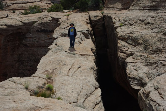
Needing a way to show the scale of the top of the arch, Jackie offered to walk out for another shot of herself.  Probably hard to see but she is not smiling right here!  The longer you stand there the narrower the top gets; trust us it's true.

A little closer shot, but what's she saying?  "Take the damn picture so I can get off of here."

From the top of the bridge you can look back west and just see Broken Arch about in the center of this shot.  What was interesting that if approached from the northwest you can locate the arch, but if you come from the southwest or east you can's see it until you are on top of it.

We (Dick) decided that the best way to get to the bottom was to follow the fins to the northwest and then follow a wash down to the bottom.  So one last shot from this side and off we go again to get to the bottom of things, pun intended.

We had to travel a good quarter of a mile before finding an area where we could get into the wash.  Well we made it down but it took over an hour working our way over dead trees, huge rock falls, loose sand and rocks.  Several times we got to a point where we had to go back up the hill and find another path. 

The closer we got to the bottom the steeper it got.  We finally got to a point that we knew we could not get back up the wash so had to find a way down.

But we did take the time to stop and smell the roses, well at least one cacti growing out of the cryptobiotic soil.  So, does a flower grow in the desert even if no one sees it?  You bet!

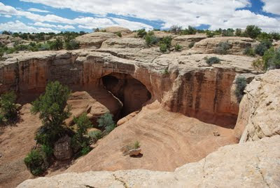
As you can see by this picture we did finally make it to the bottom; not sure how, but in one piece.  Look closely as there is another picture of Jackie.

Dick was able to crawl up between the arch and the back wall, finding a shelf to very carefully walk out onto so he could have at least one picture of himself in this blog.


Facing the bridge from the bottom we found a steep but quick way up to the top for one final shot from the other side of the Bridge.  Sure wish we had tried to get down from this side as it would of saved an hour of hard hiking.  Oh well, now you know if ever trying to get to the bottom of Magic Mystery Bridge go down from the end to the southeast corner.

Thanks to the help of Google Earth we were able to locate the bridge and finally find it.  With the added detour it took us about 3 hours but should have been 2 including a lunch stop and lots of pictures.

Just to the left of the M in Magic you will see a black line, this is the space between the bridge and the wall.


A few details for all those arch hunters out there:
The Bridge was found in 1962 when a pipeline was run through the park.  Originally called Pipeline Arch but was changed and labeled in 1975
It's span is 95' long an the top is 11' wide.  (It really feels a lot narrower when you are standing there)
It has a 62' opening between the spans.
It is 12' away from the solid wall at the top.
It has a 48' opening below the span.
And it's location is:
38 46' 17" N
109 34' 23" W

If you should decide to view this normally unseen bridge, please take the extra time to stay off the cryptobiotic soil and stay to the washes and slickrock.  This soil has been growing for hundreds of years and one step will put and end to it's life.

Need more details on location or route, send us a message.  This is a very special Bridge as very few people get to see it because of it's location and difficulty in locating it.  We feel very blessed to have found it.  And now to walk some more to keep from getting stiff--

To be continued...

Friday, May 20, 2011

Capital Reef National Park, Utah

Dick's dad used to use the saying "going on a bus-mans holiday", meaning that when the bus driver would take a holiday he would go for a bus ride.  Being camphosts at a National Park, that's what we did on our last days off.  We visited a National Park and a National Monument.  Actually we visited 2 National Parks and one National Monument in one day but that's another story.

Our days off started on Sunday with a trip to Moab for church and then off for about 150 miles to a hotel near Capitol Reef National Park.  We arrived, unpacked and headed off into the park to check a little of it out.  As you can see, it was a clear day with a few clouds and lots of red rocks. 

As we approached the park we got a feeling of the magnitude of the hills.

Another view looking down at the river in the bottom of the canyon from a great vantage point.

A trip into the visitors center with more of the hills in the background.

Very interesting combination of texture and color throughout the park; what a site to see.


A view through the juniper trees to the hills in the distance, again notice the colors at the base.

Here we go again with the Jeep up a narrow back road into a wash and canyon.  Looks like the rock bugs have been at work on the side of this hill.

As we are about to leave a narrow spot in the slot canyon.


More rock bugs at work on the hillside.
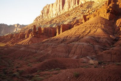
On the way back to the hotel we caught some shots just before sunset.


On the second day when the weather wasn't as nice, we took another day trip around the park, south to the town of Boulder on Hwy 12 and then east through a small part of Grand Staricase-Escalante National Monument (another Blog posting), across the southern end of Capital Reef, took a left going north now back to the hotel.  This is called "Loop the Fold" and covered over 127 miles.  It was an incredibly beautiful drive and we would recommend it to anyone.  More of the color in the hills while going back into the park.

And a little closer, the red looks out of focus but it's not.

This is one of the pictures you have to click on to view the switchbacks we had to go down.  When you get to the bottom and look back it's so steep you can't see where the road goes down.
Another trick picture for you to figure out.  No one ever comments on these so we will tell you now what it is.  Take a look before scrolling down and see if you can figure it out.


For thousands of years the smooth surfaces of the side of some of the cliffs turned very dark; this has been called desert varnish.  The Native Americans used these surfaces to chip or paint what are called petroglyphs or pictographs.  But in this case a large section fell off the side and ended in the middle of a wash where through the years some of the desert varnish was washed away leaving this interesting pattern.  The size here is about 4' wide.  Fun to shoot and fun to share these unique pieces of nature.

To be continued..                                                                                                                   

Monday, May 9, 2011

Starting 4 years on the road at Arches National Park

Happy anniversary to us!!! We celebrated the start of our 4th year on the road and still have a lot to see of this beautiful Country of ours. Jackie retired April 30, 2008 and the next day we departed on our journey. So stand by for some statistics before we share more pictures of our latest adventure. As most of you know, we switched from a Big Sky Montana 5th wheel to an Allegro Bus in October of last year.

In 3 years we have spent at least one night in 25 states
We pulled the Big Sky 21,002 miles
We drove the Allegro 5,175 miles
Sight seeing we drove the truck 38,074 miles
And sight seeing in the jeep 7,502 miles
Total miles driven 71,753 or an average of 23,918 miles per year

We visited 170 campsites, averaged 154 miles between sites and stayed an average of 6.44 days at each site.
Shortest stay was one night and longest was camp hosting at Arches National Park for 2 months last year.

We posted 211 Blog’s and had 28,340 hits.

And for the final statistic, we took (saved) an average of 95 pictures at each stop for a grand total of 16,211 pictures. So with that we hope you enjoy some of the first pictures starting year four of our travels.
---------------------------------------------------------------------------------------------------------
Well, here we are back camp-hosting at Devils Garden Campground at Arches National Park for the months of May and June, but will try a share totally different pictures that when here last year.  We don't plan on taking any pictures in the snow as we did last year.

We arrived and spent a few days visiting with our friends Robbie and Alice, and when they moved out of the host site on May 1 we started work and moved into site 35 the same day.  Thanks Robbie for all the firewood you saved for Jackie.

This gives you an idea of the size of our site and the view we have.  We have water, sewer and Park solar power.  A large concrete pad to plant the rig and Jeep on.  And a nice fire pit for campfires in the evening, a must for Jackie (although not when it's really windy, which is has been quite a few nights).  (Can you see Jackie hanging clothes on the rack Dick built for the ladder?)

Day one we took off back country hiking with Alice to try and locate Magic Mystery Bridge and on the way we visited Broken Arch.
Headed down a wash following Alice's GPS coordinates.  She and Robbie have tried 2 or 3 times to find this bridge and failed.  Could it have anything to do with bad coordinates?
Alice ahead with hands on hips, should have been a sign but we kept on going.  We never did find the bridge but we hope to get back out there another time when Dick's knees are feeling better and we have the proper location.  Thanks Alice--we had a ball.
Back in camp for the evening sunset onto the sandstone fins throughout this beautiful park.
We had company come and visit for about a week and did several hikes with Mike and Gwen.  Mike got this shot of Dick in Skyline Arch.  What the picture fails to show is the heavy wind blowing through the arch and the 300' drop off on the other side.
Dick and Mike headed off to Tapestry Arch on a short hike and got Mike to pose to show the size.
On another day all four of us headed off to the windows section of the park.  If you click on the picture you can see the people inside of Double Arch.  Another warm sunny day for a great but short hike.
And one last hike before our friends have to leave, we took them to Park Avenue and hiked the one mile down through a wash with the magnificent fins on both sides as the sun was about to set.
Half way through Park Avenue we continued to see this unbelievable scenery.
And where did this large flowering plant come from in the middle of nothing but rock?
One last shot as we head out of the wash and back to the car.
On the way back to camp we stopped and took a shot looking back at the evening shadows.
 And finally the evening sun setting behind Klondike Bluffs and then back to camp for a nice fire and firepies.

To be continued...