As we posted in an earlier blog, our friends Robbie and Alice had searched for Magic Mystery Bridge here at Arches National Park with no luck. On another day we searched with Alice and still came up empty handed. Alice had got a GPS location from a website that was wrong. Robbie searched on top of the slickrock and we searched in the washes, nothing.
With a little more research on Dick's part, he located other GPS coordinates and found it's location on Google Earth, so off we went today with our trusty GPS in hand. I think we failed to mention that Dick forgot the extra batteries and by the time we needed it, all we had were dead batteries.
Dick was able to take the batteries out of his camera and put them into the GPS until the Bridge was found and then switch back so we could post this blog with pictures.
We headed out of the campground with Jackie taking the lead down between the fins, knowing that it was our duty to find and share this soon-to-be great find. Look closely as this is one of many pictures of Jackie in this posting.
We had to stop and enjoy the beautiful view looking out across the LaSal Mountains.
We got to Broken Arch going east, took a right down into the wash, being careful to stay off the cryptobiotic soil by staying on the slickrock and the washes. With compass in hand we tried to head due east from Broken Arch. This path took us downhill but brought us on top of the slickrock. In just about 15 or 20 minutes we look to our right and see the large canyon that Magic Mystery Arch was at the head of.
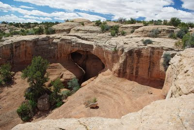
Then there it was, or at least we could see the top of it. This shot is from the top of the Bridge looking north- east into the lower canyon. The rock in the lower right hand corner is the top of the bridge.
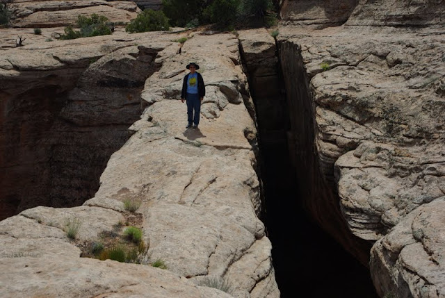
Needing a way to show the scale of the top of the arch, Jackie offered to walk out for another shot of herself. Probably hard to see but she is not smiling right here! The longer you stand there the narrower the top gets; trust us it's true.
A little closer shot, but what's she saying? "Take the damn picture so I can get off of here."
From the top of the bridge you can look back west and just see Broken Arch about in the center of this shot. What was interesting that if approached from the northwest you can locate the arch, but if you come from the southwest or east you can's see it until you are on top of it.
We (Dick) decided that the best way to get to the bottom was to follow the fins to the northwest and then follow a wash down to the bottom. So one last shot from this side and off we go again to get to the bottom of things, pun intended.
We had to travel a good quarter of a mile before finding an area where we could get into the wash. Well we made it down but it took over an hour working our way over dead trees, huge rock falls, loose sand and rocks. Several times we got to a point where we had to go back up the hill and find another path.
The closer we got to the bottom the steeper it got. We finally got to a point that we knew we could not get back up the wash so had to find a way down.
But we did take the time to stop and smell the roses, well at least one cacti growing out of the cryptobiotic soil. So, does a flower grow in the desert even if no one sees it? You bet!
As you can see by this picture we did finally make it to the bottom; not sure how, but in one piece. Look closely as there is another picture of Jackie.
Dick was able to crawl up between the arch and the back wall, finding a shelf to very carefully walk out onto so he could have at least one picture of himself in this blog.

Facing the bridge from the bottom we found a steep but quick way up to the top for one final shot from the other side of the Bridge. Sure wish we had tried to get down from this side as it would of saved an hour of hard hiking. Oh well, now you know if ever trying to get to the bottom of Magic Mystery Bridge go down from the end to the southeast corner.
Thanks to the help of Google Earth we were able to locate the bridge and finally find it. With the added detour it took us about 3 hours but should have been 2 including a lunch stop and lots of pictures.
Just to the left of the M in Magic you will see a black line, this is the space between the bridge and the wall.
A few details for all those arch hunters out there:
The Bridge was found in 1962 when a pipeline was run through the park. Originally called Pipeline Arch but was changed and labeled in 1975
It's span is 95' long an the top is 11' wide. (It really feels a lot narrower when you are standing there)
It has a 62' opening between the spans.
It is 12' away from the solid wall at the top.
It has a 48' opening below the span.
And it's location is:
38 46' 17" N
109 34' 23" W
If you should decide to view this normally unseen bridge, please take the extra time to stay off the cryptobiotic soil and stay to the washes and slickrock. This soil has been growing for hundreds of years and one step will put and end to it's life.
Need more details on location or route, send us a message. This is a very special Bridge as very few people get to see it because of it's location and difficulty in locating it. We feel very blessed to have found it. And now to walk some more to keep from getting stiff--
To be continued...


2 comments:
Hey Great on you two. I haven't heard about the living soil. Need some more learning... Heading for Hells Canyon in the morning. Right now here it is thunder and lightning and raining. You two take care and be careful. Don't want to see your story as a sad movie.. love bro and bride
Wow! That was quite a hike! So glad you found that bridge. Not sure I would attempt that kind of hike, so it was really nice looking at the pictures you took!
Post a Comment